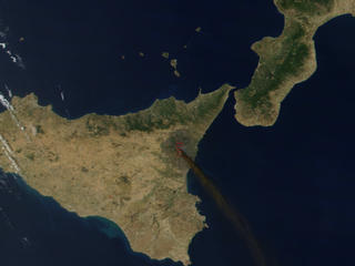
Mount Etna (also known as Mongibeddu in Sicilian and Mongibello in Italian, a combination of Latin mont- meaning mountain and the local word for beautiful) is an active volcano on the east coast of Sicily, close to Messina and Catania. It is the largest active volcano in Europe, currently standing about 3,326 m (10,910 ft) high, though it should be noted that this varies with summit eruptions; the mountain is 21.6 m (71 ft) lower now than it was in 1865. It is the highest mountain in Italy south of the Alps. Etna covers an area of 1,190 km² (460 square miles) with a basal circumference of 140 km. This makes it by far the largest of the three active volcanoes in Italy, being nearly three times the height of the next largest, Mount Vesuvius.
Mount Etna is one of the most active volcanoes in the world and is in an almost constant state of eruption. Although it can occasionally be very destructive, it is not generally regarded as being particularly dangerous, and thousands of people live on its slopes and in the surrounding areas. The fertile volcanic soils support extensive agriculture, with vineyards and orchards spread across the lower slopes of the mountain and the broad Plain of Catania to the south. Due to its history of recent activity and nearby population, Mount Etna has been designated a Decade Volcano by the United Nations.
Name and legends
Volcanic activity at Etna began about half a million years ago, with eruptions occurring beneath the sea off the then coastline of Sicily. 300,000 years ago, volcanism began occurring to the southwest of the present-day summit, before activity moved towards the present centre 170,000 years ago. Eruptions at this time built up the first major volcanic edifice, forming a strato-volcano in alternating explosive and effusive eruptions. The growth of the mountain was occasionally interrupted by major eruptions leading to the collapse of the summit to form calderas.
From about 35,000 to 15,000 years ago, Etna experienced some highly explosive eruptions, generating large pyroclastic flows which left extensive ignimbrite deposits. Ash from these eruptions has been found as far away as Rome, 800 km to the north.
Thousands of years ago, the eastern flank of the mountain experienced a catastrophic collapse, generating an enormous landslide in an event similar to that seen at Mount St. Helens in 1980. The landslide left a large depression in the side of the volcano, known as 'Valle del Bove' (Valley of the Ox). Research published in 2006 suggests that this occurred around 6000 BC, and caused a huge tsunami which left its mark in several places in the eastern Mediterranean. It may have been the reason that the settlement of Atlit Yam (Israel), now below sea level, was suddenly abandoned around that time. (Pareschi et al., Geophys. Res. Lett., 33, DOI:10.1029/2006GL027790)
The steep walls of the Valley have suffered subsequent collapse on numerous occasions. The strata exposed in the valley walls provide an important and easily accessible record of Etna's eruptive history.
The most recent collapse event at the summit of Etna is thought to have occurred about 2,000 years ago, forming what is known as the Piano Caldera. This caldera has been almost entirely filled by subsequent lava eruptions, but is still visible as a distinct break in the slope of the mountain near the base of the present-day summit cone.
Historical eruptions
Over the last 2000 years, activity at Etna has been generally effusive, with occasional explosive eruptions from the summit. Its most destructive eruption during this time occurred in March 1669, when an estimated 830,000,000 m³ of lava was ejected. The eruption was preceded by two months of increasingly powerful earthquakes centered on the southern slopes of the mountain, which eventually encouraged most villagers there to abandon their homes. On 11 March, a 9 km-long fissure opened up on the southern flank of the mountain, stretching from an elevation of 2,800 m down to 1,200 m. Activity steadily migrated downslope, and the largest vent eventually opened near the town of Nicolosi. The cinder cone built up at the erupting vent became known as Monti Rossi (red hills), and is still a prominent landmark today.
Nicolosi was quickly destroyed by lava flows, and two nearby small villages were also destroyed during the eruption's first day. The eruption was extremely voluminous, and a further four villages were destroyed in the following three days as the lava flowed south. In late March two larger towns were destroyed, and the lava reached the outskirts of Catania in early April.
At first, lava piled up against the city walls, which were strong enough to withstand the pressure of the flow. However, while the city was temporarily protected, lava flowed into its harbour and filled it in. On 30 April, lava flowed over the top of the city walls, which then gave way. Catanians built walls across major roads to halt the flow of the lava, which were fairly effective but did not prevent the destruction of the western side of the city.
During the eruption, Catania residents also attempted to divert the flows much further upstream. According to a possibly apocryphal tale, their efforts were met with armed resistance from the citizens of a town which would have been threatened by the diverted flow [1]. Whether this event really occurred or not, a law was subsequently passed to forbid the artificial diversion of lava flows. This law was only repealed in 1983.
Recent eruptions
Volcanic Seven Summits
Mountaineering

No comments:
Post a Comment